Vaughan Virginia Land Grants
Grants on-line at:
http://198.17.62.51/collections/LO.htmlGrant name
VA County
Description and Card Number
Acreage
Grant Date
Vaughan, Abraham
Amelia
On the lower side of
Saylor's Creek #3
525
1-12-1746
LunnenburgBeginning at John
Twitty's corner on a branch of the 2
nd fork of
Lickinghole #4
400
9-5-1749
On the heard branches of the
Horsepen Creek, adjoining his own lines #5
400
8-15-1764
Cornelius
King and Queen
Beginning near the head of the great meadow #10
288
4-29-1693
See Jones, Thomas & Vaughan, Cornelius #11
420
4-20-1694
Edward
NansemondAdjoining the land of Sylvester Baker, Randolph
Crecive, Richard Parker & c. #18
100
5-11-1666
Evan
SpotsylvaniaIn the little fork of
Rappahannock river; beginning at 3 white oaks standing on the north side of the North fork of the
goard vine river #21
70
6-20-1733
George
Brunswick
In the fork of Eagle's Nest Creek # 22
290
10-1-1747
Hanover
Adjoining Anthony Winston, Marjory Pate & his own land # 23
142
2-20-1723
LunenburgOn the branches of Eagles Nest Creek & the branches of Taylor's Creek #24
400
5-12-1759
Henry
(old)
RappahannockAdjoining the land of Major George Morris, James Vaughan & Thomas Gaines. On the head of a Deep Valley or
botton issuing out of a branch of
Hoskins Creek # 28
375
10-21-1684
Amelia
On the upper side of Flatt Creek #27
182
10-1-1747
SouthhamptonOn the south side of
Nottoway river, adjoining William
Bittle, and Richard Kirby Jr. #29
85
7-10-1755
On the north side of
Meherin river, adjoining William
Bittle,
Sephen Powells, William Kirby and extending #30
136
8-16-1756
IshamAmelia
On the East side of the long Branch that makes out of the Hurricane Creek #31
55
7-20-1768
James
Brunswick
#32 On the north side of
Maharin River
115
10-13-1736
#33 On a branch of Three Creeks
31.5
9-1-1783
Montgomery
#36 On Mud river a fork of
Guyandott waters of the Ohio adjoining & above a Survey made for Jacob Myers
1400
11-27-1787
Halifax
#35 On Peter's Creek adjoining Comer's land
400
7-5-1774
James Jr.
Brunswick
#40 On the north side of the south fork of Reedy Creek
378
6-16-1727
John
Accomack#44 Bounding Northerly on a small Creek,
pting. The same from the land
belonging to the Company "Lease for 21 years"
30
7-20-1639
Halifax
On both sides of Little Straight Stone Creek adjoining Edward Hubbard #49
392
7-15-1760
LunnenburgOn both sides of Reece’s fork of
Twitty’s Creek adjoining Jone’s line. #52
400
8-20-1760
Lower Norfolk
#53 On the South side of Black water creek, beginning and continuing by a
poquoson side
221
10-9-1675
#54 Being in
Curretuck Precincts on the north side of the
Blackwater river. Beg.g & c. corner tree of Henry
Southens.
300
4-20-1685
Pittsylvania#55 On the branches of Straight Stone Creek adjoining Dillard, Hubbard & c.
182
5-1-1780
Prince George
#56 On both sides of Rockey Branch on the lower side of
Mawhipponock Creek Patents 27, p. 302
37
9-5-1749
John,
et alKY Military District
#57 On the northwest of the Ohio and on the waters thereof beginning & c. lower back corner to George Washington’s survey no. 403
1000
5-29-1792
#58 On the northwest of the Ohio, beginning & c. upper back corner to Edmund
Clarks survey no. 1679 and in the line of Richard C.
Andersons survey no. 1677
822
5-29-1792
John & John Rea
New Kent
50
po: Beg.g & c. by Mr.
Burnet’s line of marked trees; thence & c. on the N: Wt. Side of
Burchen Swamp #59
130
1-15-1662
Joshua
Lunnenburg#63 On both
sides of a branch of Sanson’s fork of the
Horsepen Creek, adjoining Jeremiah White’s lines Pat. 36 p. 855
400
9-16-1765
Lewis
Amelia
#2 On the head branches of Tomahawk and Franks Creek adjoining the lines of Robert Vaughan & others. Pat. No. 31 1751-56 p. 671
244
9-10-1755
Matthew
Montgomery
#3 On Mud River a fork of
Guyandotte waters of Ohio about 2 miles from the mouth. Grants 15, p. 50
4967
11-27-1787
Nathaniel
Montgomery
#6 On the Knob fork of Elk Creek, a branch of New River Grants 35, p. 473
170
8-3-1796
Reubin & Stephen
Lunnenburg#8 On the head of Anthony’s Branch, & on the lower side of Pine Creek. Pat. 34, p. 411
795
8-10-1759
Richard
Brunswick
#9 On the north side of
Waqua Creek Pat. No. 12, 1724-26 p. 528
342
7-7-1726
#10 On the south side of
Waqua, on the
Beaverpond Branch Pat. No. 14, 1728-32 p. 76
255
9-28-1728
Charles City
# 11 See Vaughan, William and Vaughan, Richard, undated Pat. 8, 1689-95 p. 149
281
10-15-1698
Northhampton#13 At
Octopannock creek,
boging at a small branch on the Easternmost side of Edmond
Scarburgh’s land Pat. 2, p. 179
300
10-15-1649
#14 At
Occahannock creek, Beg.g. at the Easternmost part of a former dividend, granted to Richard Vaughan Pat. 2, p. 329
350
7-20-1651
Robert
Amelia
#15 On the lower side of Flatt Creek. Pat. No. 19, 1739-41 p. 933
800
3-24-1740
Prince Anne
#17 High land and marsh, lying at
Gilberts point on the Eastward side of the North River. Pat. 8, p. 443
243
4-21-1695
Samuel
Prince George
#19 On the lower side of the Middle Seller fork of Deep Creek adjoining West, Dennis and c. Pat. 17, p. 131
353
7-20-1735
# 20 On the lower side of George’s Branch of
Nummisseen Creek pat. 22, p. 534
317
9-20-1745
Sarah
Pittsylvania#21 On the branches of Fly Blow Creek, Adjoining
Farriss land. Book A, P. 289
149
5-1-1780
ShadrackKentucky Co.
#22 On the waters of
Elkhorn Creek, a north branch __ of the Kentucky River & about 25 miles from __ Same & about 95 miles from the Ohio __ on the south side thereof. Grants A. p. 96
2000
10-17-1779
Stephen
Isle of Wight
#23 On the South side of
Nottaway river. Beg.g & c.
on the north side of the 3 Creeks; thence & c. over the run of the Reedy branch. Pat. 15, p. 357
50
11-21-1734
Stephen &
ReubinLunnenburg#24 On the Head of Anthony’s Branch, & on the lower side of Pine Creek Pat. 34, p. 411
795
8-10-1759
Thomas
Amelia
#25 On both sides of Frank’s Creek of Flatt Creek Pat. No. 17, 1735-38, p. 390
400
8-15-1737
Cabell Co.
#26 On the waters of Mill Creek. Beg.g & c corner to a survey of 200
acs. Made for
Edmunc McGinnis Grant 68, 1819 p. 300
40
8-2-1819
Henry
#28 On the head branches of Horse Pasture Creek adjoining
Redmonds line. Grants G, p. 205
300
9-1-1782
Nansemond#31 at the head of the flat Cyprus swamp of
Sumerton Creek Pat. 10, p. 301
142
10-31-1716
#32 At a place called Hackney marsh. Pat. 16, p. 263
362
9-10-1735
Pittsylvania#33 On the branches of Fly Blow Creek, adjoining John Short’s land Pat. 39, p. 294
369
2-16-1771
Surry#34 On the north side of
Nottaway river; beginning & extending on the west side of
Harwood swamp. Pat. No. 32, p. 296
204
11-12-1753
Sussex
#35 On the North side of
Nottaway river. Beginning at the
Hardword run of the county line. Pat. No. 34, P. 820
100
2-14-1761
Timothy
Halifax
#36 On the branches of Ellis’ & Catawba Creeks. Pat. 33, p. 582
400
7-4-1759
William
Brunswick
#38 On the north side of Three Creeks Pat. No. 27, 1748-49 p. 503
441
12-15-1749
#39 On the north side of Three Creeks. Pat. No. 29, 1749-51, p. 136
602
6-1-1750
#40 On the south side of
Meherin River Pat. A, 1779-80, p. 373
50
6-8-1780
Charles City
#43 On the South side of
Appamattox river. Adjoining the land of
Thos. Lowe, John Evens, Wm. Johnson & the
Ballows &c. Pat. 7, 1679-89, p. 30
1225
4-20-1680
Isle of Wight
#46 On the south side of
Nottaway river, & on the north side of the Three Creeks. Adjoining the land of Adam
Taplay.
400
5-25-1734
Lunnenburg#48 Adjoining Henry Greens land on Buffalo. Pat. 33, p. 55
400
8-16-1756
Montgomery
#49 On the Knob fork of Elk Creek, adjoining Wades land. Grants 25, p. 58
200
9-12-1791
Lower Norfolk
#50 In Elizabeth river parish, Beg.g. & c. by a branch side of the head of a creek. Pat. 7, p. 497
72
4-20-1686
#51 On Tanners creek precincts. Beg.g & c. a corner tree of John Elders. Pat. 7, p. 664
220
4-23-1688
Prince George
#52 On the upper side of the Reedy Run of
Arthurs Swamp. Pat. 17, p. 128
348
7-20-1735
#53 On the south side of
Nammisseen Creek, adjoining Claiborne & Fitz. Pat. 27, p. 139
400
2-10-1748
Russell
#54 On the north side of Little Cedar Creek Grants 31 p. 108
70
8-13-1794
Surry#55 On the south side of
Nottaway river, and on the north side of Three creeks, adjoins land of Charles Kimball. Pat. No. 15, p. 233
400
5-25-1734
Washington
#56 On the forks of Little Cedar Creek and the waters of Big Cedar Creek the waters of Clinch River. Grants 28, p. 304.
400
5-16-1793
Westmoreland#57 On the eastward side of a Creek called Fishing Creek, adjoining Thomas Pope. Pat. No. 5, 1661-1666, p. 42
156
3-23-1664
William & Richard
Charles City
#58 On the west side
Mounouseneck Main Swamp. By a note in the margin of record are the following words, "Not signed" & c. Pat. 8, 1689-95, p. 149
281
1689-1695
Prince George
#59 On the upper side of Arthur's swamp adjoining his other lands. Pat. 15, p. 225
150
5-25-1734
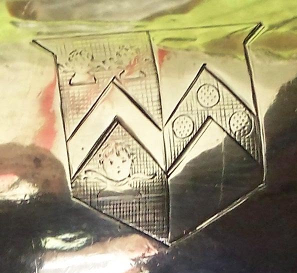
Photo: This set belongs to the Vaughan line and he would like to know the meaning of the Cress on the tea pot etc. See the Cress page in Genealogy Connection. THIS IS HIS PHOTO;
http://genealogyconnections.blogspot.com/2008/01/coat-of-arms-crest.html see: comments
You can see the more
influent often
engrave their Family Crest on their silver (gold etc.), which was a way of
accumulation wealth, like our silver gold money. Marking them to detour
thieves of this era.
http://www.fleurdelis.com/meanings.htm There are far too many links on the Internet who charges money to research your Coat of Arms or Crest's.


 VAUGHAN SHIELD